Geocaching

We learned about Geocaching in the winter of 2003, a few months after we got our GPS. If you're not familiar with what Geocaching is, essentially, it's a treasure hunt. People set up 'caches' or 'treasures', they share the coordinates of these caches online, and other people, such as ourselves, search for these caches.
www.geocaching.com gives a much better description of it in their faq. They're also the place where people post where their cache is and the outcome of a cache search.
Below are the cache's we've gone to and either found or attempted to find. Click on the links to see how we did, any pictures, notes or observations we may have taken and links to other information related to the particular area we explored.

Sept. 5, 2005
San Jose, CA
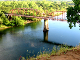
Along the De Anza Trail 10 - Camden Oak
Link to the geocaching website
A cache along this historic 'trail'.
Although it is tough to see where exactly the De Anza trail is, there are lots of plaques and markers letting you know where it was. This is one of a series of caches we plan to place along this route. You can find out more about the De Anza Trail here.
This site has been under construction for a long time and is finally completed. There is a cool piece of art nearby that we thought about making this into a multi with but in the end decided not to. You are looking for a camo paint pot that is just hanging around. Gently pop the top off to retrieve the logsheet.

June 4, 2005
Emigrant Wilderness
link to the geocaching website
The waterfall is well worth the hike when it's running. It is 50 feet high and 6 feet wide. This waterfall is known mostly to locals.
After leaving a main parking area it is 1.6 miles to a large bridge. Go across the bridge and take the trail to the right. It is unmarked, but well-defined.
The total journey to the falls area is 2.23 miles. The journey through the meadows will remind you of the movie "A River Runs Through It"; the river apparently has good trout fishing.
June 3, 2005
Fair Oaks, CA
link to the geocaching website
A monument to a structure that has been part of the community in one form or another, for over 100 years.
This beloved structure has stood the test of time. To this very day, it continues to serve the community. On any given day, you'll find families out for a stroll, folks trying to get in some exercise, people just sitting and enjoying the day, and even a few people taking part in an 'alternative commute.'
To "find" this cache, please email me with the answers to the following questions. As always, please don't post your answers as part of your visit.
1: Why was this structure originally built?
2: When was it completed??
3: How much did it cost to build??
4: What happened here in 1907, 1915, and 1967??
5: This marker was built as part of a project. What was the project??

May 22, 2005
Clark Fork and Hwy 108 near Kennedy Meadows
|
N 38° 21.787 W 119° 52.259 link to the geocaching website This waterfall is a companion to Waterfall #1. The cache is about 2x3x6 and is camo in color. In the spring this waterfall will astound you with the volume of water cascading down. There is a large area near the bridge for viewing the water closeup, and you can even walk under the bridge if you're daring enough. Warning ! These falls and the rocks above them can be dangerous. The area under the bridge is especially not recommended for small children ! Notice the tree in the picture; it's about 20 feet long with a 3 foot diameter trunk and is lodged in the middle of the waterflow. Shows you how much water goes through there. |
|
N 38° 20.435 W 119° 49.601 link to the geocaching website Small army de-con container that is fairly well packed with stuff. Seems there are quite a few hard to get caches out this way. So, we placed another easy drive by type. Bill and I finally settled on a SAFE and easy spot to place the cache. Please, stay up on the road. No need to climb or jungle jim the bridge. This old bridge still stands and the new one passes right next to it. Close parking available. Check out the lower landing area of the old bridge. You can see far into canyon and river. I'll bet this looks spectacular during spring run off. I've just got to come back to see. |

May 14, 2005
Mt. Provo and Lyon's Reservoir
|
N 38° 00.710 W 120° 12.397 link to the geocaching website Standard 2-wheel drive vehicle can drive within 1/4 mile on reasonably good gravel and dirt roads. Last 1/4 mile definitely 4WD, dirt bike or walk. Hey, I can see my house from up here! I decided our neighborhood needed a cache of its own. Camo painted coffee can. We're fast food junkies so some of the contents are toys from kids meals. Assorted other things. $1.00 Carl's gift certificate and bicentennial Kennedy half dollar for FTF. The area maps are deceiving. Due to several locked gates the only way to approach this is from Tuolumne Rd. North @ Cedar Springs or Hill Haven in Ponderosa Hills. |
|
N 38° 05.554 W 120°
10.123 Located near Lyons Dam in Tuolumne Co. Just 2 miles off HWY 108. Lyons Dam stores drinking water for much of Tuolumne Co., so no swimming is permitted here but fishing is allowed. This is a very beautiful area to Hike/Bike/Fish with plenty of parking & Restroom facilities,Picnic tables & a few BBQ's. If you come earlier in the year you can see & hear the roar of the water as it tumbles over the Dam creating beautiful rainbows. Go down below for a cool refreshing spray. Cache is larger than a micro but smaller than a regular & is pretty well concealed. It initially contains a Log book, Geocoin, & a few other small items for trade. Please bring a Pen/Pencil. Difficulty can vary between 2-4 depending on your vestibular function. May not be suitable for very small children, however most seem to enjoy this walk. It's challenging, fun & you can walk for miles along this area. We come here quite often & really look foward to doing this walk & enjoy the scenery very much. There are also 2 other caches nearby to find. Enjoy this hunt & bring a camera! |

April 10, 2005
Marin Headlands
Jimmy and I tried this one last year but failed. We brought Lauree with us this time and she was just the good luck charm that we needed to find it!
N 37° 49.604 W 122° 31.098
link to the geocaching website
This is a micro-cache in the Marin Headlands. Plan on spending the day with the magnificent views of the bay, the gate, the city and the wide blue Pacific. While you are here, there just happens to be several caches along this stretch of road.
On my way back to the car after not finding a plundered cache in the woods, I decided to place this log only cache right near (vertical? horizontal?) the road. Remember to bring your own pen.

March 20th - 26th, 2005
Washington D.C.
We managed to log 9 geocaches during our DC trip!! Actually, it was easy to bank geocaches because they were all virtual since leaving a physical cache at the National Mall or at Arlington National Cemetery isn't allowed.
(click on title of cache for more information and photos)
|
N 38° 53.753 W 077° 01.945 link to the geocaching website
|
N 38° 53.707 W 077° 02.194 link to the geocaching website
|
N 38° 53.386 W 077° 00.591 link to the geocaching website
|
|
N 38° 53.753 W 077° 01.900 link to the geocaching website
|
The
View of an "Honest Man" link to the geocaching website
|
N 38° 53.308 W 077° 00.758 link to the geocaching website
|
|
N 38° 53.706 W 077° 02.179 |
N 38° 53.483 W 077° 00.634 |
N 38° 52.830 W 077° 04.389 |

February 14, 2005
Reno, NV
This couldn't have been a more perfect way to spend Valentine's day in Reno.
|
N 39° 33.292 W 119° 49.906 You always wondered what that giant green sort of thing was, and now you have a reason to find out. The history of the Basque in Nevada is one of the states many exciting chapters. This cache is a reason to learn more about it. For more check out the Center for Basque Studies and you can learn all about the Basque Country here. The Cache is pretty easy to find, but some general hunting will be required. BE sure to read all the plaques along the way to get the full picture of the region. Cache includes some Nevada casino trinkets, that are, simply, must HAVES! Check it out for yourself :-) |
|
N 39° 33.369 W 119°
49.481 Park on the dirt turn out south of the dam on old 395. From there it's a short and easy walk to the cache. I drive by here often and it makes me curious.
Curiosity
kills the cat, but I'm curious about.....
The cache is
a pint size clear plastic container. |
|
N 39° 27.908 W 119° 48.310 link to the geocaching website This is an easy cache which not only gives you a great view of the city, but gives you a "taste of reno." This cache is meant to be a type of "recipe exchange." Inside, you will find a variety of delicious and time-tested recipes. If you want to exchange, please bring a recipe either typed or neatly hand printed on a 3x5 notecard. Please visit this cache as many times as you want to find new recipes. Also, please don't just throw in any old recipe from a magazine.. let it be one that you make personally and that you think others will enjoy! Enjoy and happy cooking (and caching!) PS - Please be on the lookout for broken glass. The park is obviously a popular spot for "bottle flinging." |
|
A Wonderful Bird is the Pelican N 39° 27.437 W 119° 44.089 link to the geocaching website This is an easy suburban cache. You can drive to within a few feet but you will enjoy it more if you park on the pavement and walk to the cache. Notice - You won't see many birds in the winter so come back in the spring, summer, or fall.
A wonderful
bird is the pelican -Dixon Lanire Merrith in his poem "The Pelican" (1910)
We moved to Reno in 2002 and expected to find a desert. Instead we discovered a wonderful outdoors playland. We love the close proximity to the mountains and the river. One of our nicest discoveries was that the wetlands near our home contain some amazing and surprising creatures. One of our best discoveries was “Alexander Lake” which is on the North East corner of the Double Diamond Ranch housing development. We were pleased to find the abundance of water birds there including White Pelicans, Great Egrets, and White-Faced Ibis. This is not a themed cache. We decided to use this cache for all the non-reptiles that end up in our “Don’t Tread on Me” cache on Rattlesnake mountain. Please take and leave whatever you want. There are some pictures and articles about the pelicans for you to read. Enjoy the area. |

October 10, 2004
Las Vegas, NV
|
N 36° 11.100 W 115° 26.113 link to the geocaching website Red Rock canyon area If you would like to see some ancient art in Las Vegas this one's for you. I've heard for a long time there's no culture in Vegas. Depends on what your looking for. This is a piece of Ancient Indian Art in Nevada. Many caches out here, but nobody stops to see this Pictogragh. Ancient Indian cave paintings out in the open for every one to see. I enjoy it, and it's one of my son's favorites. Please email me with the date and act which protects this site. Please nothing in the logs. Thanx |
|
N 36° 11.048 W 115° 25.679 link to the geocaching website
This area is
getting harder to get to. Twenty-five years ago you could drive to the
reservoir, now you have a hard time getting off SR-159 into the area. As
with the series along the southwest hills, development is encroaching on
the area. Either 4x4 or high clearance is needed through the washes to
get to the caches. |

July 24th and 25th, 2004
Mendocino
|
Russian Gulch link to the geocaching website Nice park and a good trail. We were on bikes when we hid this one. Park at the trail head. Container: large coffee can |
|
N 39° 20.914 W 123° 49.581 link to the geocaching website My friend sagefox posted a virtual cache at a lighthouse recently so I thought I would post one “too”! This virtual cache site coordinate will place you at a great whale watching location when they are migrating up or down the coast. I would also like to point out that the building right behind you is one that my friend Stefan and I worked on. We did the restoration of the lantern; the part that encloses the Fresnel lens. We completely disassembled and reassembled that cast iron brass and glass structure. If the building is open you can see the photos. To verify that you were at this virtual cache site would you please e-mail me the color of the roof. Don't post the answer here, even if encrypted. |
|
Glass Beach 2 link to the geocaching website This cache is located at a popular beach on the North end of Fort Bragg. Park in the parking lot at N 39 27.120; W 123 48.572 and follow the trail for about 3/10 mile to the final coordinates. You will drop down approx. 15' to sea level. This is a small cache in a round plastic container. It is in a fairly public area so you will have to be discreet. |

July 12, 2004
New Melones Reservoir
N 37° 57.844 W 120° 30.210
link to the geocaching website
If you don't have feet like those of Christ, then you're gonna need a boat!
Used the Labor Day Weekend to combine some of our favorite activities: Wakeboarding, water skiing, hiking, camping, star gazing, and geocaching. My three year old daughter made the hike from the shoreline to the cache site, so what are you waiting for? Our second hide at the lake, again a gorgeous view. Literally hundreds of deer trails on the island, some right next to the cache.

June 18, 2004
Palo Alto
|
N 37° 26.360 W 122° 09.237 link to the geocaching website The information on this cache is extensive, so please click on the title above or here for all the details. |

June 14, 2004
San Juan Capistrano
|
Micro Cache Primer link to the geocaching website Just a quick, easy cache. Wheelchair accessible! A simple micro-cache, perfect for a first cache. The difficulty is 1 because you can't set it lower. Also intended to truely be wheelchair accessible. May be the simplest cache you ever do! Altoids tin, painted to blend into surroundings. Feel free to trade something if the lid will close; not much room in an Altoids tin. |
|
Geocache Colour Clash link to the geocaching website Off of Del Obispo...You can park right next to it in the lot.....70ft altitude....NOT in the Armstrong Nursery.
Microcache in
a magnetized keyholder. |
|
N 33° 29.411 W 117° 40.534 link to the geocaching website Did you know you can have your own garden too? This is a simple micro cache in an alumin tin... Although I knew this area like the back of my hand... I didn't know this garden oasis was here.Have fun finding this cache, and be careful... there are many people around. |

June 12, 2004
Irvine
|
N 33° 39.808 W 117° 51.200 link to the geocaching website Fairly easy to get to, with adjacent metered parking. Paths are both paved and gravel, with some parts somewhat hilly. This is one of those caches that brings you to a spot you may not have ever discovered on your own, but you will want to return. Started in 1964 as a nursery to supply the landscaping needs of the University as it was being constructed, the Arboretum now maintains a collection of rare and endangered plants from a variety of California habitats. Over 200 endangered species are maintained and actively propagated. But be forewarned, the Arboretum has some restrictive hours, making this a good cache to visit on your lunch hour, or on a Saturday. It is opened from 9:00 am to 3:00 pm, Monday through Saturdays. It is closed on Sundays and major holidays. On occasion, they have special events to raise funds for their work, where you can purchase bulbs, poinsettias, and perennials. There is usually no admission fee, unless they are holding one of their fundraising sales. On those days (about 4 per year), it may cost around $2. Even so, the place is well worth admission. (There is also a donation box, if you want to support their work). PLEASE respect the property! The Arboretum is visitor friendly, and the staff are aware of the cache, so you do not have to worry about being caught. But you should not have to do any bushwhacking to find the cache. This is the only officially approved cache in the Arboretum. You are looking for a round Altoids Tangerine drops can, so the items inside are small. Bring your camera...or even your lunch for a picnic. This is an unexpected treat just off of a major busy highway in the heart of the busy SNA airport area. *Update 4/13/2004: We upgraded the container, to make it more watertight. It is a larger "Snapware" 1.5 cup plastic container... clear right now, but we will return to camo-paint it next week. Good luck! |
|
N 33° 39.775 W 117° 50.770 link to the geocaching website This is an excellent family walk and prettiest in the morning or late afternoon. Just about .35 mile from the parking lot. This area is open from dawn to dusk. No dogs or bicycles are allowed within the sanctuary. The area is best reached by taking Riparian Way all the way to the end and parking in the lot for the sanctuary. This cache is a film canister containing a log book. Please bring your own pen to log in. You do not need to disturb the sensitive plant life to find the cache, but it is covered. I'm still rating it a 1 even though it is a micro-cache. |
|
Dawgs Life link to the geocaching website Cache is on the top of a hill over looking Irvine. I put a few things in for the Dawgs. |

June 10, 2004
Bakersfield and Apple Valley
|
N 35° 22.328 W 119° 00.490 link to the geocaching website Two questions: What can you do to it? Who is in the silly quote under it?
I love taking
the train. My goal is to set caches in all of the stations I go to with
a stop long enough to set or find one. |
|
Jurassic Park link to the geocaching website The cache location is very visible so be very discreet, and remember this is the desert, so there are critters lurking nearby.
I moved to
the High Desert about twenty years ago when there were fewer homes. The
area where this cache is hidden was on a route that some friends and
myself used to take our dune buggies to a sand hill where the new
cemetery now lives. Our route took us past some dinosaur replicas made
out of cement. I always wondered what the story was behind these. When
you post your report please share any information you might have, as I
know there are Geocachers in the High Desert that have been residents
much longer than Red Lady or myself. |

May 21-22, 2004
Yosemite
Eric organized an amazing "Yosemite 2004 Adventure" weekend and we gave ourselves an extra day for geocaching. We attempted and found 3 geocaches on Friday and found 1 on Saturday, during the 'big' hike.
Since most of the caches we did have so much information on them, click on the title of the cache below for more details and our pictures.
|
A
Happy Place |
|
N 37° 43.854 W 119° 33.509 |
|
Yosemite Valley High Water – The 100 Year Flood |
|
N 37° 43.636 W 119° 32.599 |

May 2, 2004
We did 2 geocaches today and explored the area a lot more.
|
N 38° 05.666 W 120° 10.107 link to the geocaching website There are Deer Crossings, Duck Crossings, and even School Crossings. Watch out for the Lyon Crossing. It's an ammo can stashed in the woods. The walk is short but you can always keep walking and see where the trail goes. I've ridden mountain bikes in the area and the trails are difficult and not for beginners. You can fish near by, but NO SWIMMING. There is plenty of space to park. The drive in can be a little bumpy but it's doable by most cars. The gate which let's you drive to the area will be closed Oct. 31st. There are other ways into the area but they require longer walks. If there is no snow on the ground, you should be able to get to the cache. There are other ways to get into the area, they just require more hiking, biking, or 4WDing. |
|
SierraHeights N 38° 20.546 W 119° 55.523 link to the geocaching website Inspiration point, if ever there was such a thing. Be prepared for one of the most exotic views that the Sierra Nevadas can offer from the relative comfort of 1/4 mile from you vehicle. Best time is sunset to twilight and remember that the winds can get very COLD in the evenings. Extra bonus if you can spot the remnants of an ancient glacier that carved the walls of the canyon. Careful on the edge and not recommended if you have fear of heights. |

April 25, 2004
Tuolumne
We did 5 caches today and found 4! Yay!! Our find average is up!
|
"
Take A Hike" link to the geocaching website This is A hiking trail on a old rail road bed, near Tuolumne City. This is a tupperware container about 3in by 6in camo color very easy no stickers and no climbing. You can park your car at N 37-58-385 W 120-13-616 Their two more cache A short drive down the canyon. |
|
N 37° 59.038 W 120° 12.335 link to the geocaching website This is a micro cache. Please bring a pencil. I don't know why but I have this thing with areas like this. I just cannot resist putting a cache in these areas. Maybe it has to do with that gloomy warlock feeling |
|
N 37° 58.097 W 120° 13.975 To honor those before us.
Went by this a number of times. This was the
first time I stopped to see what it was. I've used these before not in work
but play. This is a great tribute to them. (this was our 2nd attempt at this one. We found it this time). |
|
The Marble Orchard This is the drug free part of town. Just a quiet neighberhood. This is A black 35mm film canister with short pencil and log just your name and date. It's easier to walk around than to drive in this park, narrow roads that end. |
|
Lava Dump Located in brush a bit off the end of a paved/closed road. I think the location is at the tail-end of the Lava flow that I placed LAVA MAMA upon...but not sure. You're here for the view...best at sunset or by the light of a full moon. The distant city lights of the Central Valley twinkle like diamonds (at night). This location is not too exciting during the day, as it is located at an old dump. If you want to know where to park to access this one, read the clue. |

April 17, 2004
|
N 38° 11.604 W 119° 59.604 This location is near a beautiful lake with a gorgeous background of granite rock carved by glaciers. Please email us the answers to the questions before posting your find. You may post your find after we e-mail you back confirming your correct answers. Do not post your answers on the cache page. Thank you and enjoy the area!! #1 What object is at this location? #2 What do you see if you are facing east? #3 N 38 11.480 / W 119 59.592 -What large object is near this location? |

April 10, 2004
Los Gatos and Campbell Area
|
Secret Walkway #2 - Gato de Callejón N 37° 14.984 W 121° 57.625 A cache on a hidden little walkway. Sometimes there are walkways that seem to have no real purpose. This series of caches highlights the ones we've come across. We placed this cache as an inside joke for Aargnzarf & Kikipopo. They will definitely have a few laughs with this one. Hopefully you will too. |
|
OakHill PlayLot A very nice little park in a quiet neighborhood with the play lot stuff, nice grass area and dog bags – my human loves those. It is a mess kit with a frog, 2 butterflys, 2 marbles, a super ball and a bull. No pen inside - bring your own pen. Please cover it up again like you find it (hopefully covered up) It is near a gas station - I was in the car when my human was getting gas and I saw the grass. Woof Woof - can we go, please? |
|
N 37° 14.710 W 121° 57.560 This object is something you wouldn’t normally see in Los Gatos. You do have to open the gate to reach this cache. I was thinking I would make this a virtual cache but I don't like virtual caches. I wasn’t too sure about this spot for a cache but I wanted geocachers to see this object. This is a sign only cache and bring your own writing utensil. I found some more info on this object but don't look at this link until you find the cache. The info will spoil the surprise! |
|
N 37° 14.739 W 121° 57.231 4/16/03 This used to be a multicache but I have changed it to a traditional cache and lowered the difficulty and terrain ratings. I have also changed the coordinates to reflect the final location, using numbers that Marky gave me. Enjoy.
This cache is
being placed in honor of my son Andy, who turned 5 on Tuesday, March 18. |
|
Secret Walkway #3 -
Over 85 The posted coordinates are not the actual coordinates of the cache, but the cache is within 528 feet of the posted coords. This walkway isn't too big of a secret, although I bet most people haven't been on it before. This is a bit different from the others in this series, because this one has a puzzle to solve before finding the cache. I was contemplating some new caches that required a lengthy hike to get to and came up with the following: GPS + (K * CACHE) = HIKING There are multiple solutions (thanks to Jif and Kablooey for pointing this out to me). To help you narrow down the possible solutions, use only solutions that have K < C
The cache can be found at: The cache is a small M&M plastic container. It contains a cache pen, a log sheet/stash note and a few VERY small trade items. Think SMALLER than a marble. |
|
Campbell Park Troll A cache is back in this park. Great Park. Has dog poop bags and seems to be easy on dogs off leash. Cache is about 5 x 5 x 1.5 camo box. Cache location is not wheelchair accessible. A troll lives in the area and has his stash of Army men, Tabasco Sauce, play dough and the Woody Snail TB hidden here. What other things does a troll keep? It is in a fairly difficult spot to find (I think) so that others will not find it and trash it again. You will be able to find it without people seeing you if you are careful. The lid needs to be put back on with a bit of wiggling to get it to stay. |

April 3, 2004
Marin Headlands
-5:51am - sunrise over Mt. Diablo and San Francisco. Exploring Battery Spencer
-6:44am
|
The Big View This location can be reached by car, mountain bike, or your own legs. So the difficulty ranges from 1 to 5 depending which you choose.
This is a 35mm film canister with a magnet on
the side. |
-6:51am
|
Marin Headlands Two Like Marin Headlands One this is a terrific view... but even better. You will drive most of the way but will get to take a short hike up a steep path. Look for the path to the south side of the hill top. Once on top, you must find a 8" steel pipe extending 6" out of the ground. The end has been sealed with concrete. In it, one word and a date are inscribed. To log the cache, email me the word and year in the concrete. |
-8:05am
|
N 37° 49.604 W 122° 31.098 This is a micro-cache in the Marin Headlands. Plan on spending the day with the magnificent views of the bay, the gate, the city and the wide blue Pacific. While you are here, there just happens to be several caches along this stretch of road. On my way back to the car after not finding a plundered cache in the woods, I decided to place this log only cache right near (vertical? horizontal?) the road. Remember to bring your own pen. |

March 14, 2004
|
Lava Mama My mom told me about the view from this area, so I just had to place a cache here. I placed it on Mothers Day after taking her to breakfast, thus the "Mama" reference. You'll figure out the "Lava" reference when you look around at this location. Hope you enjoy the view. |

March 1, 2003
|
N 37° 58.097 W 120° 13.975 To honor those before us.
Went by this a number of times. This was the
first time I stopped to see what it was. I've used these before not in work
but play. This is a great tribute to them. |